Mild Monday Afternoon, Rain Returns Tuesday, & a Cold Thanksgiving Ahead
BRIDGEPORT, W.Va (WDTV) -
Monday:
Expect widespread morning lows ranging from the upper 20s to low 30s. Patchy, dense fog is likely during the morning hours, but it is expected to dissipate by 10 AM. Cloud cover will gradually increase throughout the day due to approaching frontal activity from the west. A three-day stretch of above-average high temperatures will begin on Monday. Highs will be dependent on latitude, ranging from around 60° in Sutton and Glenville to the mid 50s in Fairmont and Morgantown.
Tuesday:
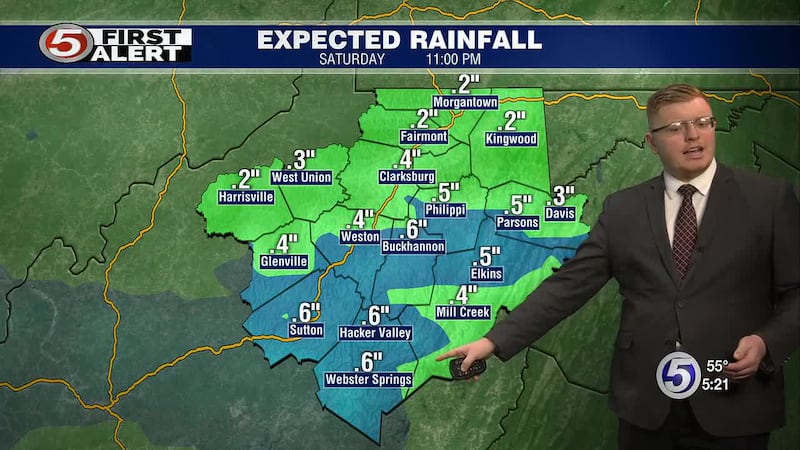
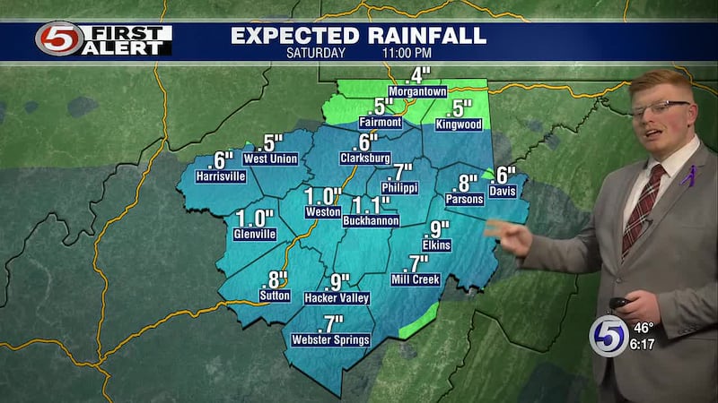
The aforementioned frontal activity, tied to multiple areas of low pressure advancing into the eastern US, will spark a widespread rainfall event. Expect most rainfall totals on Tuesday to range from 0.25 to 0.75 inches. Highs will likely range from the low 60s in Sutton and Glenville, to around 60° in Morgantown, Clarksburg, and Elkins, and low to mid 50s in Davis.
Wednesday:
Expect additional rain showers on Wednesday as a potent cold front makes its passage over NCWV. A stiff wind will pick up during the afternoon hours as this occurs. Highs will likely range from around 60° in the lowlands to the low to mid 50s in Davis.
Thursday - Thanksgiving Day:
Behind the passage of the aforementioned cold front, temperatures will plummet just in time for the holiday with regionwide morning lows in the 20s. Highs will likely only rise into the mid to upper 30s in the lowlands (coldest north) and will likely stay below freezing above 2500′ of elevation. These temperatures will be paired with a stiff westerly wind, resulting in afternoon wind chills in the 20s in the lowlands and teens above 2500’.
Friday:
Morning lows will likely be down in the low to mid 20s in the lowlands and teens in the mountains. Pair these temperatures with the aforementioned wind, and you get wind chills in the teens in the lowlands and single digits in the mountains. Highs will remain well below average again on Friday, likely ranging from the mid to upper 30s in the lowlands (coldest north) and staying below freezing above 2500′ of elevation.
Copyright 2025 WDTV. All rights reserved.